GIMS – A revolutionary geospatial data platform
GIMS – The Platform
Geospatial Intelligence Management System (GIMS) is developed for rapid and efficient dissemination of data across and between organisations. Supporting the highest security demands for interoperability between NATO countries.
GIMS is accredited and in use by Norwegian Armed Forces with proven world class interoperability performance at CWIX.
Core Geospatial System
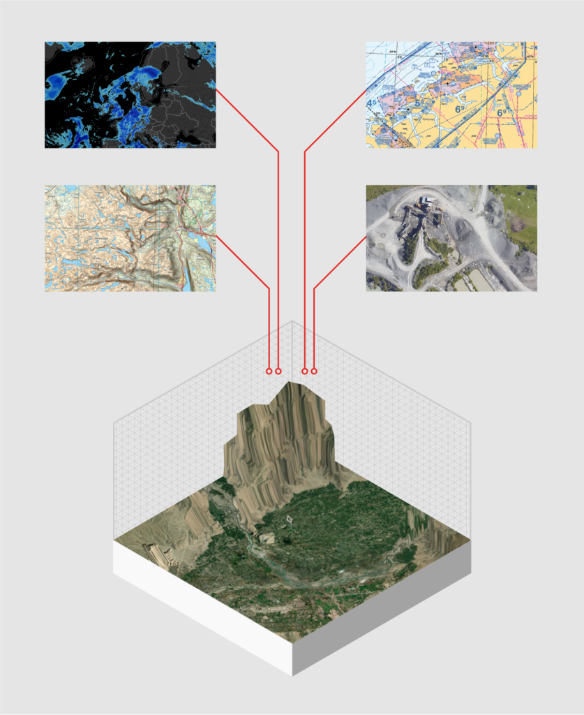
GIMS acts as a secure central geospatial data library, handling 100+ data formats and crawling external sources. Supporting multiple forces, locations and missions, GIMS is the perfect platform for managing and disseminating data.
Scalability
Each installation is configured and integrated to meet our customers’ highest demands on information security and interoperability, whether cloud based or on-premises installation. Based on well-proven concepts such as caching, clustering, load balancing, distribution and delegation, GIMS provides unlimited scaling both vertically and horizontally.
Interoperability
GIMS secures rapid and efficient dissemination of data across and between organisations, employing advanced cataloguing of all data and metadata following NATO and OGC standards. “Fighting off the same map” is achieved by connecting defence organisations’ geosystems from command and control to specific mission clients.
Security
For our customers, security is central to their operations. With that in mind the foundational design principle behind GIMS is that a data set should only be registered one time. GIMS then automatically distributes the data, making it available specifically to authorised users.
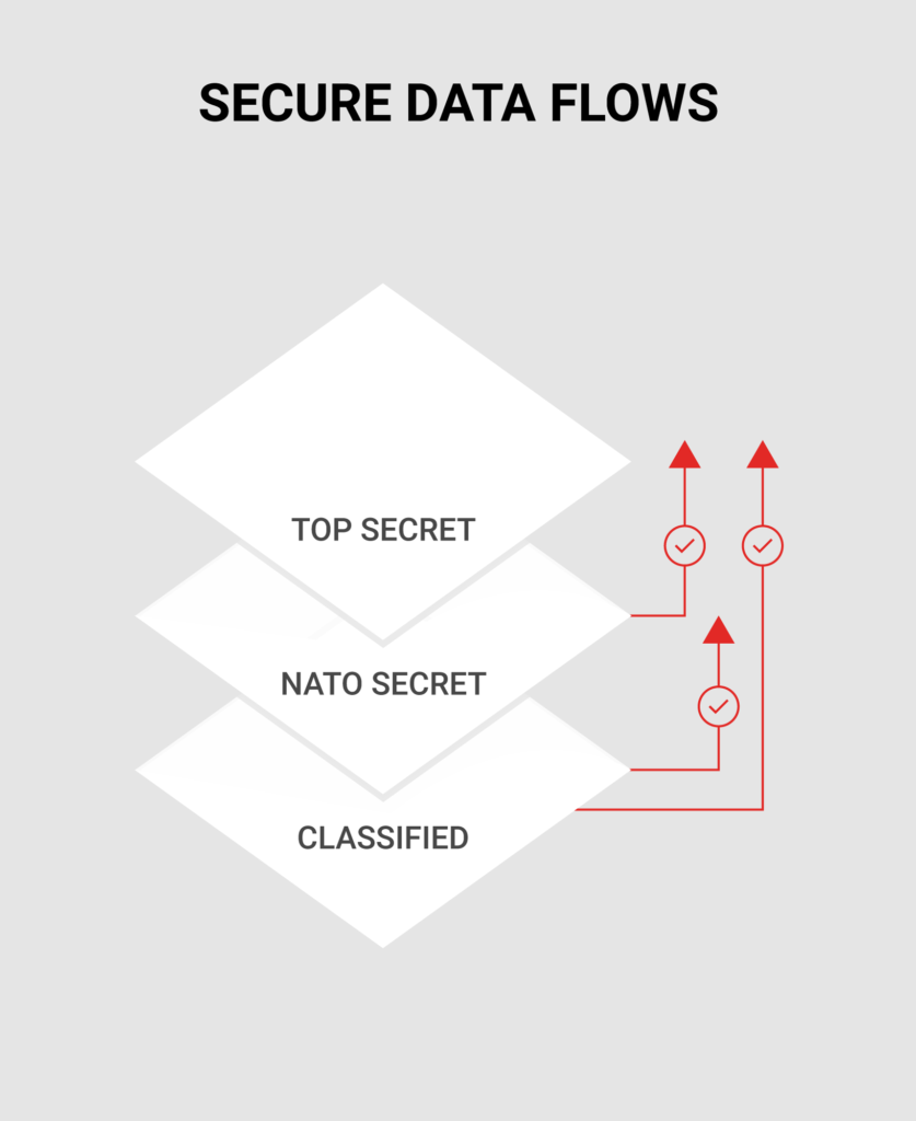
Secure Data flow
A unique feature within GIMS is the data pump system, which enables secure sharing of data to higher and lower security levels (encompassing everything from open internet up to and above NATO Secret). An advanced diode system secures data flow between security levels and organisations.
Fine-grained security
Fine-grained security supports role based and individual appointed access to a dataset. This adds a new dimension to your ability to direct and steer security access to data sets associated with specific classified operations.
Data assurance
GIMS offers manual and automated rule based quality assurance of all data in a multi-user environment. Data sets with low quality levels can be combined with validated information giving users and decision makers confidence that content is accurate, current and relevant.
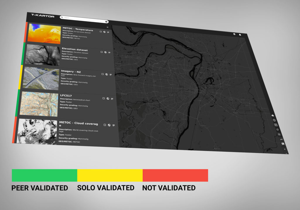
Traffic light system
GIMS uses a traffic light coded data assurance logic allowing all data to be assessed and quality rated for controlled use pending full validation. The traffic light system allows accredited users to approve foundation data via a configurable workflow. Three levels apply: red, yellow and green – where green is the highest and fully assured data with associated geodata services.
This assurance system allows non-assured open data to be evaluated and reviewed in coordination with validated information, giving users and decision makers confidence that content is current and relevant.
Advanced cataloguing
All data is made accessible and searchable to registered users, whether stored locally or elsewhere. Features include automated crawling and publication of web-services. Multiple GIMS instances are synchronised with each other and between security levels in real time. Built-in functionality for storage optimisation includes identification of duplicates and redundancies.