

Five Ways Geospatial Technology Is Changing Agriculture
Technology is pivotal in addressing various industry challenges in today’s rapidly evolving world. One such sector benefitting from cutting-edge technological advancements is agriculture. With our planet’s growing population, ensuring people have access to food is a big priority for agriculturists. This blog post will explore five ways geospatial technology revolutionizes agriculture and transforms food production. These five ways are just a few – the intersection between GEOINT and agriculture is advancing daily.
Optimizing Crop Yields
Maximizing crop yields is paramount in pursuing global food security. Geospatial technology, particularly satellite imagery and remote sensing, is critical in achieving this goal. Farmers can implement precision farming techniques by monitoring crop health and identifying stress factors. Geospatial tools enable farmers to analyze soil data, weather patterns, and historical crop performance using GIS. This data-driven approach enhances decision-making, leading to optimized crop yields and reduced resource waste.
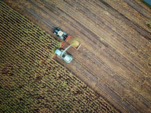
GPS for Farmers
Precision agriculture has transformed farming practices, and GPS technology has been at the forefront of this revolution. GPS-enabled machinery and equipment, such as tractors and harvesters, enable farmers to operate efficiently and accurately. GPS technology makes precise field mapping, variable rate application of fertilizers and pesticides, and efficient irrigation practices possible. This saves time and resources and minimizes environmental impact, resulting in sustainable agricultural practices.
Livestock Monitoring
Livestock health and welfare are paramount for successful farming operations. Geospatial technology provides invaluable tools for livestock monitoring. GPS-enabled collars and tags allow farmers to track and manage their animals effectively. Real-time location data helps monitor grazing patterns, detect anomalies, and ensure optimal animal health and nutrition. By leveraging geospatial technology, farmers can make informed decisions to improve livestock management practices and enhance overall productivity.
Insect Control
Controlling insects and pests is a perpetual challenge in agriculture. Geospatial technology offers innovative solutions for targeted pest management. Satellite imagery and GIS analysis can accurately identify areas susceptible to infestations. Farmers can implement precision spraying and integrated pest management strategies with this knowledge. Geospatial technology reduces environmental impact by minimizing pesticide use and adopting more targeted approaches while ensuring effective insect control.
Nutrient Distribution and Management
Efficient nutrient distribution and management are vital for crop health and productivity. Geospatial technology and GIS play a significant role in this aspect. By analyzing soil nutrient levels and other relevant data, farmers can develop tailored fertilizer application plans. Precision agriculture techniques ensure that crops receive the precise amount of nutrients they need, reducing waste and optimizing nutrient uptake. This not only improves crop yields but also contributes to sustainable farming practices .
With its powerful tools and applications, geospatial technology is transforming the agriculture industry in multiple ways. The benefits are far-reaching, from optimizing crop yields to enabling precision farming through GPS technology. Livestock monitoring using geospatial tools ensures better animal health and welfare. Insect control strategies become more efficient and targeted, minimizing environmental impact. Nutrient distribution and management practices are enhanced, improving crop productivity and sustainable farming practices.
As we look towards the future, embracing these innovations and exploring the myriad opportunities geospatial tech brings to the agriculture sector is crucial. Together, we can address global food security challenges and create a more sustainable and productive agricultural landscape.
Connect With T-Kartor
Beyond agriculture, geospatial technology brings benefits and innovations to countless areas. At T-Kartor, our expert teams work on projects and development in defense, innovation, satellite imaging, and more. If you are interested in working with us or have any geospatial questions, contact us today!


