The Benefits of Geospatial Technology for Infrastructure Planning and Management
The structures of cities, suburbs, and even rural areas constantly evolve. In recent years, geospatial technology has become increasingly crucial for infrastructure planning and management, as it provides powerful tools for mapping and understanding complex systems, including transportation networks, water and energy systems, and other critical infrastructure. GIS analysts worldwide are also focused on improving city wayfinding with GIS tools. Let’s explore some key benefits of geospatial technology for infrastructure planning and management.
Improved Decision-Making
One of the main benefits of geospatial technology for infrastructure planning and management is improved decision-making. GIS systems allow users to easily collect and analyze data from multiple sources, including satellite imagery, demographic information, and other data sources.
This information can then be used to create detailed maps, models, and visualizations that help decision-makers understand the complex relationships between infrastructure components and the environment. For example, GIS can be used to analyze the impact of new infrastructure projects on traffic patterns, water flow, and other critical factors, helping to ensure that new projects are designed and built to minimize negative impacts.
Increased Efficiency
Infrastructure planners and managers can streamline their work processes using GIS and related tools, reducing the time and effort required to collect and analyze data. This can lead to faster and more accurate decision-making and improved communication and collaboration between different stakeholders. For example, GIS can create shared maps and visualizations that help various departments and organizations work together more effectively, leading to better outcomes for infrastructure projects.
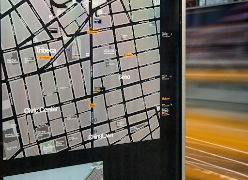
City Wayfinding
One specific application of geospatial technology for infrastructure planning and management is city wayfinding. Wayfinding refers to the processes by which people navigate and orient themselves in urban environments and is an essential factor in designing prosperous and livable cities.
Geospatial technology can create detailed maps and visualizations of city environments, helping to identify areas where wayfinding is challenging and develop strategies for improving navigation and orientation. For example, GIS can be used to analyze pedestrian traffic patterns and to design new street signs and other wayfinding systems that make it easier for people to find their way around the city.
Helsinki’s Wayfinding System
One example of a city that has successfully used geospatial technology for wayfinding is Helsinki, Finland. In the early 2000s, the city used GIS and other geospatial tools to develop a comprehensive wayfinding system that makes it easier for residents and visitors to navigate the city. The system includes detailed maps, street signs, and other wayfinding aids designed to be intuitive and user-friendly. As a result of these efforts, Helsinki has become known as one of the most navigable cities in the world and has received widespread praise for its wayfinding system.
Emergency Response
Another vital benefit of geospatial technology for infrastructure planning and management is improved emergency response. GIS can create real-time maps and visualizations of emergency situations, such as natural disasters, allowing emergency responders to assess the situation and develop an effective response quickly. For example, GIS can be used to create maps that show the location of critical infrastructure, such as hospitals, water treatment plants, and other essential facilities, making it easier for emergency responders to access these locations in the event of a crisis.

Sustainability
Finally, geospatial technology can help to improve sustainability and environmental stewardship. GIS and related tools can be used to analyze the environmental impact of infrastructure projects, helping to ensure that new projects are designed and built to minimize environmental harm. GIS tools can identify the most optimal places to run a new street or highway project based on the existing geographical elements, watershed elements, or wildlife migration patterns. Infrastructure planners and urban developers can use this data to plan projects that will be environmentally conscious.
Work With T-Kartor
Beyond infrastructure, geospatial technology brings benefits and innovations to countless areas. At T-Kartor, our expert teams work on projects and development in defense, innovation, city wayfinding, satellite imaging, and more. If you are interested in working with us or have any geospatial questions, contact us today!