The History of Geospatial in St. Louis
If you’re following the rise of the geospatial industry in the United States, chances are you have heard of the boom it’s creating in St. Louis, MO. But did you know that the St. Louis area has a storied history with the geospatial and mapping industries that started long before recent developments? The world-famous Gateway Arch represents progress and expansion, so it makes sense to have a growing industry with similar values call St. Louis home. Looking back into the past and tracing the industry’s history helps us pave the way for the future.
Pre-1960: War Efforts and the ACIC
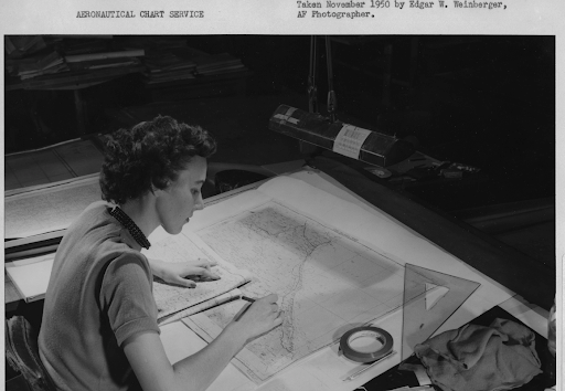
The St. Louis Arsenal, located in what is known today as North City, was founded around 1827. The Arsenal was a critical manufacturing plant of small arms and supplied the U.S. Army and American settlers of the time. From the Civil War through WWII, the Arsenal was involved in war efforts by manufacturing arms, outfitting troops, becoming a cavalry depot, and more. During WWII, civilians and military personnel began work close by the Arsenal at the Globe Building , where they would take film from spy planes overseas and triangulate them onto maps. This work led to the formation of the Aeronautical Chart and Information Center (ACIC).
1963 and 1964: Beginnings of Computerized GIS
Post WWII, cartography and aeronautical imaging work that was similar and/or adjacent to the ACIC’s was taking shape all over the country. However, it was in Canada that Roger Tomlinson’s work was used to pioneer and develop the Canada Geographic Information System – widely regarded as the first computerized GIS in the world in 1963. His work was focused on land management and how Canada could merge natural resource data from its provinces. A year later, in the U.S., Howard Fischer researched spatial analysis and visualization and created SYMAP, one of the first computer mapping software programs that influenced today’s applications.
1969: Esri Founded
After the growing progress in the GIS field, Jack and Laura Dangermond took it one step further. They founded the Environmental Systems Research Institute, Inc. (Esri), which has evolved into one of the biggest names in the industry. Esri develops GIS mapping and spatial analysis programs designed to solve problems. Many geospatial organizations, public and private, use some form of Esri products today.
1972: ACIC Becomes Defense Mapping Agency (DMA)
In St. Louis, the ACIC transitioned into the Defense Mapping Agency (DMA). This agency began producing TERCOM (Terrain Contour Matching) maps that aided precision weaponry, especially later on during Desert Storm. Even though modern precision weapons use GPS or more advanced systems now, TERCOM maps are often still uploaded in systems in case of emergencies or signal blocking. This geospatial work that was happening in St. Louis had applications all around the world.
1996-2003: DMA to NGA
In 1996, the DMA combined with the National Imagery and Mapping Agency, and then in 2003, was renamed the National Geospatial-Intelligence Agency (NGA) that we know today. The rise of technology in this period was critical, and St. Louis continued to be a major player in the industry. The NGA provided information for American soldiers, airmen, Coast Guardsmen, Marines, and more that helped them navigate their missions – and this work continues as of 2023.

2010: Geospatial Companies Call St. Louis Home
In addition to the NGA, many other geospatial companies have come to call St. Louis home in the past few decades. In 2010, our T-Kartor USA team moved its headquarters from Redlands, CA, to St. Louis, MO, to the Globe Building. The move was a great fit with St. Louis’ history and emergence as a geospatial hotspot. Additionally, being in the center of the United States has its benefits with regard to communication, logistics, and more.
2016: New NGA West Site Proposed in North City
The NGA made a groundbreaking announcement in 2016: St. Louis was chosen as the preferred location for the new $1.75 B NGA West site. Although there was initial discussion over whether the site should be built in St. Louis City or across the river in Metro East, the site in North City was chosen. The campus is being constructed at the intersection of N. Jefferson and Cass Avenues and is expected to be finished by 2026.
The Gigabyte Corridor
If you work in a geospatial-related role in St. Louis, you’re in good company: Greater St. Louis, Inc. reports that there are 53,000+ employees in these roles in the region. In addition to T-Kartor USA, a few notable employers in the metro area are Maxar Technologies, General Dynamics, Leidos, Esri, and more. With T-Kartor USA, Maxar, General Dynamics, and others having offices in the Globe Building Downtown, an innovative portion of the city is emerging called the “gigabyte corridor.”
This corridor also includes employees from Square (now BLOCK), T-Rex, and other FinTech companies. Between the FinTech presence and the Globe Building, along with the anticipation of the NGA-West site, it’s an exciting time to be in St. Louis.

Looking Ahead
From the past to the present, the talent in St. Louis has been a driving force behind the geospatial industry, which will undoubtedly continue into the future. A sense of renewal and innovation is in the air in the city. Likewise, innovations and progress are constantly brewing in the geospatial industry. Daily advancements are made in satellite imagery, remote sensing, spatial analysis, and even VR and AI integrations.
St. Louis is excited to host the 2023 GEOINT Symposium in May 2023, where over 4,000 participants from various backgrounds will come to synergize ideas and move the industry forward. If one message resonates from the past, present, and future, St. Louis is the place to be in the geospatial industry, with innovation and progress at its heart.
Work With T-Kartor USA
Geospatial technology brings innovation to our world through location intelligence, remote sensing, and much more. At T-Kartor USA, our expert teams work on projects and development in defense, innovation, city wayfinding, and satellite imaging. Our work helps decision-makers across many industries make informed choices. If you are interested in working with us or have any geospatial questions, contact us today!