
Utilizing a data-driven approach to create connected cities
Taking care of all the city’s wayfinding information needs and helping people understand the transport network. Encouraging active journeys on foot or by bike and giving people the confidence to explore.
Tjänster - Kartproduktion
We will help you plan, implement and maintain the best City Wayfinding system to suit your city’s needs. We develop legible wayfinding basemaps, either as a seamless cartographic database in a GIS or as a file-based master basemap.

Customer cases – City Wayfinding

Transport of London
Since its creation the Legible London wayfinding database has been maintained to be current and accurate, utilising stakeholder feedback from all 33 boroughs, the rivers and canals trust and several BIDs. Our online management portal has been indispensable for TfL to oversee and approve basemap updates, track information assets and plan maintenance frequencies.

New York City Department of Transportation
Our data driven basemap is especially flexible with regard to different outputs and formats, unleashing creative possibilities which can benefit many sectors of the city.

City of Toronto
The Transportation Services Division of the City of Toronto has been conscious to make the TO360 Wayfinding ‘Map Asset’ useful to as many departments as possible. Variations on the pedestrian basemap have been created for Toronto’s Bike Share system, bus stops, the underground PATH system and Toronto parks & trails.

Transport for West Midlands
T-Kartor provides a ’smart refresh’ analysis of map assets most in need of updating. This allows for an efficient allocation of resources and improved accuracy and currency of information.

Storstockholms Lokaltrafik (Stockholm Regional Transport)
In order to create the interactive Digital Wayfinding signage, live transport data feeds were integrated from all available modes. The basemap was optimised for digital outputs (due to specific resolution and formatting constraints) and the transport symbology layer was replaced by interactive objects.

Île-de-France Mobilités (Paris Region)
The production system is made available to all bus operators in Île-de-France via a custom-designed web portal. The process of ordering plans is intuitive, and the status of all orders can be easily tracked.

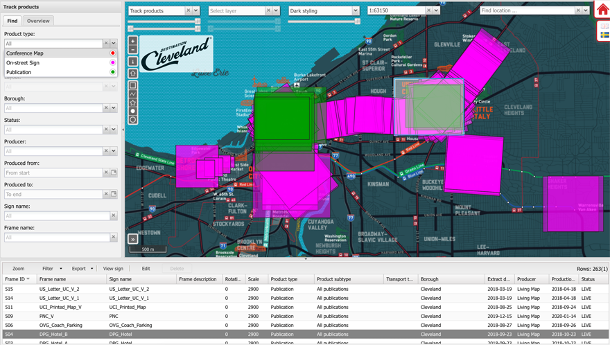
Destination Cleveland
T-Kartor provide Destination Cleveland with an online content management portal to keep track of both the mapping database and the full catalogue of wayfinding products. This keeps the centralised map data asset in sync with all customer-facing information, ensuring accurate, updated maps which is so important to maintain trust in the system.
